

Bus 19 in Edinburgh links Joppa Pans layby and Granton Square. The route is 15.5 km long with 59 stops, and the official schedule from Lothian Buses puts the full trip at about 63 minutes. On a weekday it runs 63 trips in one direction, and 45 on a weekend day.
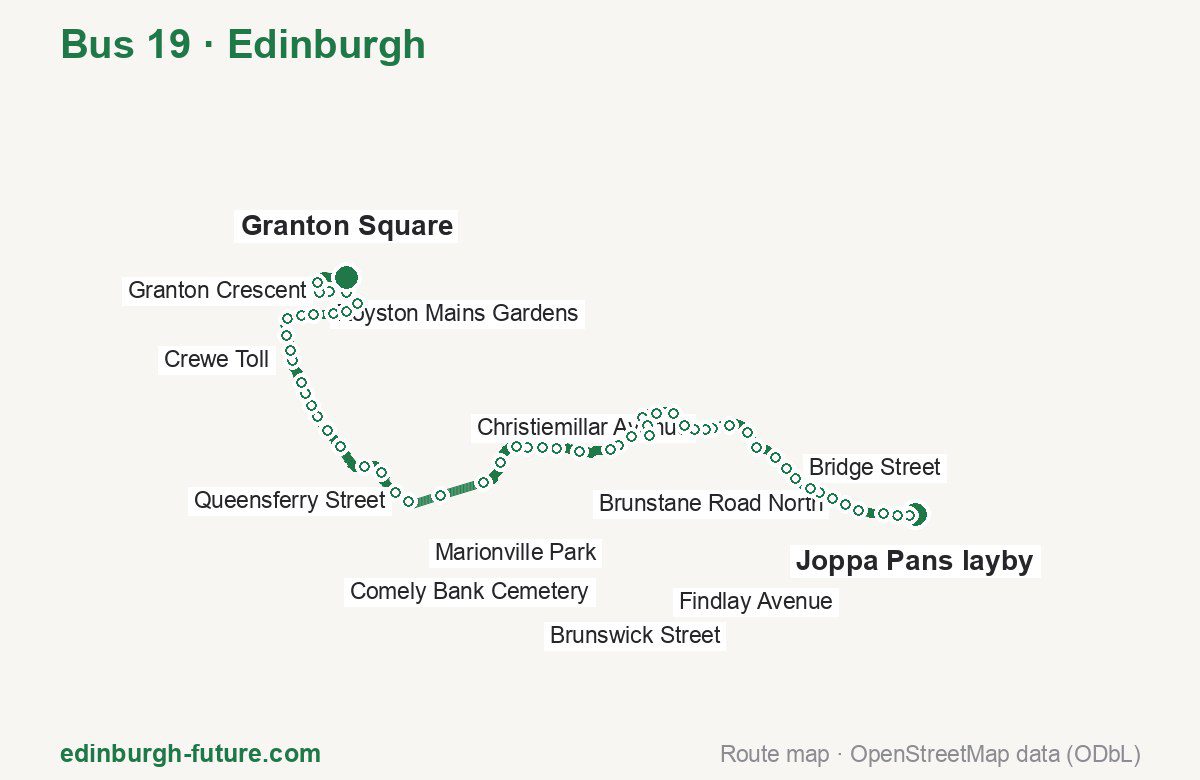
Route at a glance
| Mode | Bus |
|---|---|
| Route number | 19 |
| City | Edinburgh |
| Operator | Lothian Buses |
| Start → end | Joppa Pans layby → Granton Square |
| End → start | Granton Square → Joppa Pans layby |
| Route length | 15.5 km / 15.6 km in the opposite direction |
| Number of stops | 59 / 61 in the opposite direction |
| Travel time | about 63 minutes |
| Trips per day | 63 on weekdays, 45 on weekends one way |
| Frequency | peak 13–20 · midday 9–15 · weekend 20–32 |
| First / last trip from «Joppa Pans layby» | 05:13 / 23:26 |
| First / last trip from «Granton Square» | 05:00 / 23:27 |
| Fare | 2.40 £ (fare in effect since 22 February 2026) |
| Updated | August 22, 2026 |
Route of Bus 19
Outbound: Joppa Pans layby → Granton Square
This direction has 59 stops and runs 15.5 km. The route passes Joppa Pans, Christiemillar Avenue, Wellington Street, North Werber Park. Below is the full list with the distance from the first stop.
| No. | Stop | From start | Note |
|---|---|---|---|
| 1 | Joppa Pans layby | 0.0 km | Terminus |
| 2 | Joppa Pans | 0.1 km | |
| 3 | Seaview Terrace | 0.3 km | |
| 4 | Coillesdene Drive | 0.5 km | |
| 5 | Morton Street | 0.9 km | |
| 6 | Brunstane Road North | 1.1 km | |
| 7 | Pitville Street | 1.3 km | |
| 8 | Bellfield Lane | 1.5 km | |
| 9 | Windsor Place | 1.6 km | |
| 10 | Portobello Town Hall | 1.9 km | |
| 11 | Bridge Street | 2.1 km | |
| 12 | King’s Road | 2.4 km | |
| 13 | Portobello Road | 2.7 km | |
| 14 | Bryce Avenue | 3.0 km | |
| 15 | Vandeleur Avenue | 3.3 km | |
| 16 | Christiemillar Avenue | 3.6 km | |
| 17 | Craigentinny Crossroads | 3.7 km | |
| 18 | Loganlea Road | 3.8 km | |
| 19 | Loaning Road | 4.0 km | |
| 20 | Restalrig Drive | 4.2 km | |
| 21 | Findlay Avenue | 4.5 km | |
| 22 | Sleigh Drive | 4.8 km | |
| 23 | Restalrig Gardens | 5.0 km | |
| 24 | Marionville Drive | 5.1 km | |
| 25 | Marionville Avenue | 5.4 km | |
| 26 | Marionville Park | 5.6 km | |
| 27 | Dalgety Avenue | 5.7 km | |
| 28 | Abbeyhill | 6.2 km | |
| 29 | Brunton Place | 6.6 km | |
| 30 | Wellington Street | 6.8 km | |
| 31 | Brunswick Street | 7.0 km | |
| 32 | Leopold Place | 7.2 km | |
| 33 | Leith Street | 7.6 km | |
| 34 | Princes Street (Waverley Steps) | 8.0 km | |
| 35 | Princes Street (west) | 8.7 km | |
| 36 | Queensferry Street | 9.2 km | |
| 37 | Drumsheugh Place | 9.4 km | |
| 38 | Dean Bridge | 9.8 km | |
| 39 | Learmonth Terrace | 10.1 km | |
| 40 | Flora Stevenson School | 10.7 km | |
| 41 | Comely Bank Cemetery | 11.0 km | |
| 42 | Western General | 11.3 km | |
| 43 | West Woods | 11.4 km | |
| 44 | North Werber Park | 11.6 km | |
| 45 | Crewe Toll | 11.8 km | |
| 46 | Crewe Toll | 12.2 km | |
| 47 | Crewe Road Gardens | 12.3 km | |
| 48 | Crewe Road West | 12.6 km | |
| 49 | Boswall Parkway | 12.8 km | |
| 50 | Crewe Bank | 13.1 km | |
| 51 | Royston Mains Gardens | 13.2 km | |
| 52 | Granton Primary School | 13.6 km | |
| 53 | Pilton Crescent | 13.7 km | |
| 54 | Granton Gardens | 14.1 km | |
| 55 | Granton Terrace | 14.3 km | |
| 56 | Granton Crescent | 14.6 km | |
| 57 | Wardieburn Road | 14.7 km | |
| 58 | Granton Park Avenue | 14.9 km | |
| 59 | Granton Square | 15.5 km | Terminus |
Inbound: Granton Square → Joppa Pans layby
This direction has 61 stops and runs 15.6 km. The route passes Granton Medway, Crewe Toll, Leopold Place, Loaning Road. Below is the full list with the distance from the first stop.
| No. | Stop | From start | Note |
|---|---|---|---|
| 1 | Granton Square | 0.0 km | Terminus |
| 2 | Granton Medway | 0.1 km | |
| 3 | Granton Park Avenue | 0.3 km | |
| 4 | Wardieburn Road | 0.7 km | |
| 5 | Granton Crescent | 1.0 km | |
| 6 | Granton Terrace | 1.2 km | |
| 7 | Wardie Crescent | 1.4 km | |
| 8 | Pilton Crescent | 1.8 km | |
| 9 | Granton Primary School | 1.9 km | |
| 10 | Royston Mains Gardens | 2.2 km | |
| 11 | Crewe Bank | 2.4 km | |
| 12 | Boswall Parkway | 2.6 km | |
| 13 | Crewe Road West | 2.9 km | |
| 14 | Crewe Road Gardens | 3.0 km | |
| 15 | Crewe Toll | 3.2 km | |
| 16 | Crewe Toll | 3.5 km | |
| 17 | North Werber Park | 3.7 km | |
| 18 | West Woods | 3.9 km | |
| 19 | Western General | 4.2 km | |
| 20 | Comely Bank Cemetery | 4.4 km | |
| 21 | Flora Stevenson School | 4.7 km | |
| 22 | Orchard Brae Avenue | 4.9 km | |
| 23 | Learmonth Terrace | 5.3 km | |
| 24 | Dean Bridge | 5.5 km | |
| 25 | Drumsheugh Place | 6.0 km | |
| 26 | Queensferry Street | 6.2 km | |
| 27 | Princes Street (west) | 6.7 km | |
| 28 | Princes Street (Scott Mon.) | 7.1 km | |
| 29 | Leith Street | 7.6 km | |
| 30 | Leopold Place | 8.3 km | |
| 31 | Brunswick Street | 8.5 km | |
| 32 | Wellington Street | 8.7 km | |
| 33 | Brunton Place | 8.9 km | |
| 34 | Abbeyhill | 9.2 km | |
| 35 | Marionville Road | 9.3 km | |
| 36 | Dalgety Avenue | 9.6 km | |
| 37 | Marionville Park | 10.0 km | |
| 38 | Marionville Avenue | 10.2 km | |
| 39 | Marionville Drive | 10.4 km | |
| 40 | Restalrig Gardens | 10.6 km | |
| 41 | Sleigh Drive | 10.9 km | |
| 42 | Findlay Avenue | 11.1 km | |
| 43 | Restalrig Drive | 11.3 km | |
| 44 | Loaning Road | 11.5 km | |
| 45 | Loganlea Road | 11.7 km | |
| 46 | Craigentinny Crossroads | 11.9 km | |
| 47 | Christiemillar Avenue | 12.0 km | |
| 48 | Vandeleur Avenue | 12.3 km | |
| 49 | Bryce Avenue | 12.5 km | |
| 50 | Portobello Road | 12.8 km | |
| 51 | King’s Road | 13.2 km | |
| 52 | Bridge Street | 13.4 km | |
| 53 | Portobello Town Hall | 13.7 km | |
| 54 | Windsor Place | 13.9 km | |
| 55 | Bellfield Lane | 14.1 km | |
| 56 | Pitville Street | 14.3 km | |
| 57 | Brunstane Road North | 14.5 km | |
| 58 | Morton Street | 14.7 km | |
| 59 | Coillesdene Drive | 15.1 km | |
| 60 | Seaview Terrace | 15.3 km | |
| 61 | Joppa Pans layby | 15.6 km | Terminus |
Schedule and frequency
According to the official schedule from Lothian Buses, the route runs 63 trips in one direction on a weekday, and 45 on a weekend day.
| Direction | Weekdays | Weekends and holidays |
|---|---|---|
| From «Joppa Pans layby» | 05:13 — 23:26 | 05:35 — 23:26 |
| From «Granton Square» | 05:00 — 23:27 | 05:50 — 23:27 |
Frequency calculated from the departure table: in the morning peak buses run every 13–20 minutes, most often every 15; midday every 9–15 minutes; in the afternoon peak every 15–20; on weekends every 20–32 minutes.
Fare and payment
A single ride costs 2.40 £ — fare in effect since 22 February 2026. The same fare applies to Lothian buses in Edinburgh.
A single bus journey costs £2.40 and covers one journey only — it gives no transfer and is not valid on Edinburgh Trams. A City DAYticket is £6.00 and works on both bus and tram; contactless travel is capped at £5.70 a day.
Frequently asked questions
How much does a ride on bus 19 cost?
2.40 £ for a single ride — fare in effect since 22 February 2026.
When do the first and last trips run?
From Joppa Pans layby the first is at 05:13 and the last at 23:26. From Granton Square they are 05:00 and 23:27.
How long does the trip from Joppa Pans layby to Granton Square take?
About 63 minutes end to end — the median of full trips in the official schedule.
How many stops does the route have?
59 outbound and 61 inbound according to the official GTFS feed. The two lists do not match exactly.
Does bus 19 run on weekends?
Yes. On weekends and holidays there are 45 trips in one direction, running from Joppa Pans layby between 05:35 and 23:26.
Every route number with its termini, operating hours and travel time is collected in the Edinburgh buses overview.
Data current as of August 22, 2026. Schedule and termini — Lothian Buses. Fares — Lothian Buses. Stop list, schedule and route geometry come from the official GTFS feed (Bus Open Data Service (BODS)).