

Bus 38 in Edinburgh links Waterfront Broadway and Royal Infirmary. The route is 17.7 km long with 62 stops, and the official schedule from Lothian Buses puts the full trip at about 72 minutes. On a weekday it runs 42 trips in one direction, and 18 on a weekend day.
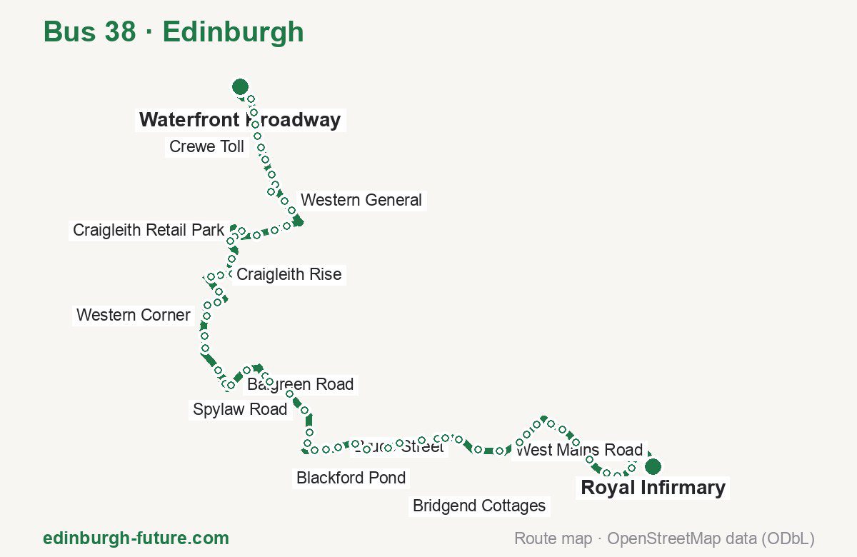
Route at a glance
| Mode | Bus |
|---|---|
| Route number | 38 |
| City | Edinburgh |
| Operator | Lothian Buses |
| Start → end | Waterfront Broadway → Royal Infirmary |
| End → start | Royal Infirmary → Waterfront Broadway |
| Route length | 17.7 km / 17.5 km in the opposite direction |
| Number of stops | 62 / 60 in the opposite direction |
| Travel time | about 72 minutes |
| Trips per day | 42 on weekdays, 18 on weekends one way |
| Frequency | peak 2–38 · midday 15–30 · weekend 40–60 |
| First / last trip from «Waterfront Broadway» | 05:17 / 21:25 |
| First / last trip from «Royal Infirmary» | 04:45 / 20:25 |
| Fare | 2.40 £ (fare in effect since 22 February 2026) |
| Updated | August 22, 2026 |
Route of Bus 38
Outbound: Waterfront Broadway → Royal Infirmary
This direction has 62 stops and runs 17.7 km. The route passes Royston Mains Crescent, Craigleith Road, Gorgie Park Road, Oswald Road. Below is the full list with the distance from the first stop.
| No. | Stop | From start | Note |
|---|---|---|---|
| 1 | Waterfront Broadway | 0.0 km | Terminus |
| 2 | Royston Mains Crescent | 0.4 km | |
| 3 | Boswall Parkway | 0.6 km | |
| 4 | Crewe Road West | 0.8 km | |
| 5 | Crewe Road Gardens | 1.0 km | |
| 6 | Crewe Toll | 1.2 km | |
| 7 | Crewe Toll | 1.4 km | |
| 8 | North Werber Park | 1.7 km | |
| 9 | West Woods | 1.9 km | |
| 10 | Western General Hospital | 2.1 km | |
| 11 | Western General | 2.6 km | |
| 12 | Comely Bank Cemetery | 2.8 km | |
| 13 | Orchard Place | 3.2 km | |
| 14 | Craigleith Hill Crescent | 3.5 km | |
| 15 | Craigleith Hill | 3.8 km | |
| 16 | Craigleith Retail Park | 4.1 km | |
| 17 | Craigleith Road | 4.6 km | |
| 18 | Blinkbonny Terrace | 4.8 km | |
| 19 | Craigleith Avenue South | 5.2 km | |
| 20 | Craigleith Crescent | 5.5 km | |
| 21 | Craigleith Rise | 5.7 km | |
| 22 | Mary Erskine school | 5.9 km | |
| 23 | Campbell Avenue | 6.2 km | |
| 24 | Kinellen Road | 6.5 km | |
| 25 | Gaurdians Wood | 6.7 km | |
| 26 | Western Corner | 6.9 km | |
| 27 | Saughtonhall Church | 7.3 km | |
| 28 | Balgreen Road | 7.5 km | |
| 29 | Balgreen Primary School | 7.9 km | |
| 30 | Saughton Rose Gardens | 8.2 km | |
| 31 | Balgreen Road | 8.4 km | |
| 32 | Gorgie Park Road | 8.7 km | |
| 33 | Sinclair Place | 9.1 km | |
| 34 | Stewart Terrace | 9.2 km | |
| 35 | Ashley Terrace | 9.7 km | |
| 36 | Spylaw Road | 10.1 km | |
| 37 | Myreside Stadium | 10.5 km | |
| 38 | Myreside Court | 10.7 km | |
| 39 | Craighouse Gardens | 11.0 km | |
| 40 | Balcarres Court | 11.2 km | |
| 41 | Bruce Street | 11.4 km | |
| 42 | Belhaven Place | 11.7 km | |
| 43 | Cluny Gardens | 11.9 km | |
| 44 | Braid Avenue | 12.2 km | |
| 45 | Midmar Avenue | 12.4 km | |
| 46 | Blackford Pond | 12.8 km | |
| 47 | Oswald Road | 13.1 km | |
| 48 | Maurice Place | 13.2 km | |
| 49 | Eva Place | 13.4 km | |
| 50 | Royal Observatory | 13.8 km | |
| 51 | West Mains Road | 14.2 km | |
| 52 | Gordon Terrace | 14.5 km | |
| 53 | Lady Road | 14.7 km | |
| 54 | Cameron Toll Centre | 15.0 km | |
| 55 | Cameron Toll | 15.3 km | |
| 56 | Bridgend Cottages | 15.5 km | |
| 57 | Craigmillar Cemetery | 15.8 km | |
| 58 | Walter Scott Avenue | 16.2 km | |
| 59 | Kingston Avenue | 16.5 km | |
| 60 | Craigmillar Castle Road | 16.7 km | |
| 61 | RH for Children & Young People | 17.0 km | |
| 62 | Royal Infirmary | 17.7 km | Terminus |
Inbound: Royal Infirmary → Waterfront Broadway
This direction has 60 stops and runs 17.5 km. The route passes RH for Children & Young people, Blackford Pond, Gorgie Park Road, Blinkbonny Terrace. Below is the full list with the distance from the first stop.
| No. | Stop | From start | Note |
|---|---|---|---|
| 1 | Royal Infirmary | 0.0 km | Terminus |
| 2 | RH for Children & Young people | 0.8 km | |
| 3 | Craigmillar Castle Road | 1.1 km | |
| 4 | Kingston Avenue | 1.3 km | |
| 5 | Walter Scott Avenue | 1.7 km | |
| 6 | Craigmillar Cemetery | 2.0 km | |
| 7 | Bridgend Cottages | 2.1 km | |
| 8 | Cameron Toll | 2.6 km | |
| 9 | Cameron Toll Centre | 2.8 km | |
| 10 | Gordon Terrace | 3.1 km | |
| 11 | West Mains Road | 3.5 km | |
| 12 | Royal Observatory | 3.9 km | |
| 13 | Eva Place | 4.2 km | |
| 14 | Maurice Place | 4.4 km | |
| 15 | Oswald Road | 4.7 km | |
| 16 | Blackford Pond | 5.0 km | |
| 17 | Midmar Avenue | 5.3 km | |
| 18 | Braid Avenue | 5.5 km | |
| 19 | Cluny Gardens | 5.8 km | |
| 20 | Belhaven Place | 6.0 km | |
| 21 | Bruce Street | 6.2 km | |
| 22 | Balcarres Court | 6.4 km | |
| 23 | Craighouse Gardens | 6.7 km | |
| 24 | Myreside Court | 7.0 km | |
| 25 | Myreside Stadium | 7.3 km | |
| 26 | Spylaw Road | 7.6 km | |
| 27 | Ashley Terrace | 7.9 km | |
| 28 | Stewart Terrace | 8.4 km | |
| 29 | Sinclair Place | 8.7 km | |
| 30 | Gorgie Park Road | 8.9 km | |
| 31 | Balgreen Road | 9.3 km | |
| 32 | Saughton Rose Gardens | 9.6 km | |
| 33 | Balgreen Primary School | 9.9 km | |
| 34 | Balgreen Tram Stop | 10.1 km | |
| 35 | Balgreen Road | 10.2 km | |
| 36 | Saughtonhall Church | 10.5 km | |
| 37 | Western Corner | 10.6 km | |
| 38 | Gaurdians Wood | 11.0 km | |
| 39 | Kinellen Road | 11.2 km | |
| 40 | Campbell Avenue | 11.5 km | |
| 41 | Mary Erskine School | 11.8 km | |
| 42 | Craigleith Rise | 12.0 km | |
| 43 | Craigleith Avenue South | 12.4 km | |
| 44 | Blinkbonny Terrace | 12.9 km | |
| 45 | Craigleith Road | 13.1 km | |
| 46 | Craigleith Retail Park | 13.2 km | |
| 47 | Craigleith Hill | 14.0 km | |
| 48 | Craigleith Hill Crescent | 14.2 km | |
| 49 | Orchard Place | 14.6 km | |
| 50 | Comely Bank Cemetery | 14.9 km | |
| 51 | Western General | 15.2 km | |
| 52 | Western General Hospital | 15.5 km | |
| 53 | North Werber Park | 15.8 km | |
| 54 | Crewe Toll | 15.9 km | |
| 55 | Crewe Toll | 16.3 km | |
| 56 | Crewe Road Gardens | 16.5 km | |
| 57 | Crewe Road West | 16.7 km | |
| 58 | Boswall Parkway | 17.0 km | |
| 59 | Royston Mains Crescent | 17.2 km | |
| 60 | Waterfront Broadway | 17.5 km | Terminus |
Schedule and frequency
According to the official schedule from Lothian Buses, the route runs 42 trips in one direction on a weekday, and 18 on a weekend day.
| Direction | Weekdays | Weekends and holidays |
|---|---|---|
| From «Waterfront Broadway» | 05:17 — 21:25 | 06:18 — 21:25 |
| From «Royal Infirmary» | 04:45 — 20:25 | 06:26 — 20:25 |
Frequency calculated from the departure table: in the morning peak buses run every 2–38 minutes, most often every 16; midday every 15–30 minutes; in the afternoon peak every 15–30; on weekends every 40–60 minutes.
Fare and payment
A single ride costs 2.40 £ — fare in effect since 22 February 2026. The same fare applies to Lothian buses in Edinburgh.
A single bus journey costs £2.40 and covers one journey only — it gives no transfer and is not valid on Edinburgh Trams. A City DAYticket is £6.00 and works on both bus and tram; contactless travel is capped at £5.70 a day.
Frequently asked questions
How much does a ride on bus 38 cost?
2.40 £ for a single ride — fare in effect since 22 February 2026.
When do the first and last trips run?
From Waterfront Broadway the first is at 05:17 and the last at 21:25. From Royal Infirmary they are 04:45 and 20:25.
How long does the trip from Waterfront Broadway to Royal Infirmary take?
About 72 minutes end to end — the median of full trips in the official schedule.
How many stops does the route have?
62 outbound and 60 inbound according to the official GTFS feed. The two lists do not match exactly.
Does bus 38 run on weekends?
Yes. On weekends and holidays there are 18 trips in one direction, running from Waterfront Broadway between 06:18 and 21:25.
Every route number with its termini, operating hours and travel time is collected in the Edinburgh buses overview.
Data current as of August 22, 2026. Schedule and termini — Lothian Buses. Fares — Lothian Buses. Stop list, schedule and route geometry come from the official GTFS feed (Bus Open Data Service (BODS)).