

Bus 3 in Edinburgh links Cook Crescent and Clovenstone Drive. The route is 28.1 km long with 83 stops, and the official schedule from Lothian Buses puts the full trip at about 106 minutes. On a weekday it runs 80 trips in one direction, and 51 on a weekend day.
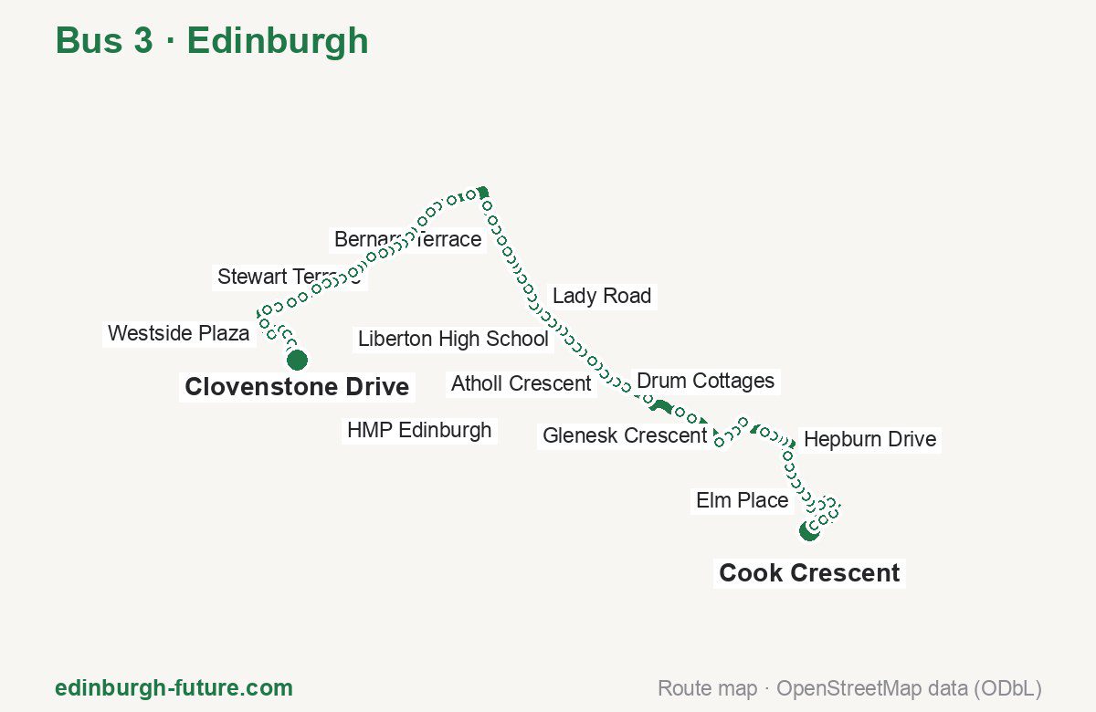
Route at a glance
| Mode | Bus |
|---|---|
| Route number | 3 |
| City | Edinburgh |
| Operator | Lothian Buses |
| Start → end | Cook Crescent → Clovenstone Drive |
| End → start | Clovenstone Drive → Cook Crescent |
| Route length | 28.1 km / 27.9 km in the opposite direction |
| Number of stops | 83 / 84 in the opposite direction |
| Travel time | about 106 minutes |
| Trips per day | 80 on weekdays, 51 on weekends one way (91 on weekdays → Cook Crescent) |
| Frequency | peak 1–17 · midday 10–13 · weekend 18–25 |
| First / last trip from «Cook Crescent» | 04:50 / 23:38 |
| First / last trip from «Clovenstone Drive» | 00:02 / 23:32 |
| Fare | 2.40 £ (fare in effect since 22 February 2026) |
| Updated | August 22, 2026 |
Route of Bus 3
Outbound: Cook Crescent → Clovenstone Drive
This direction has 83 stops and runs 28.1 km. The route passes Hill Place, Glenesk Crescent, Nether Liberton Lane, Gorgie City Farm. Below is the full list with the distance from the first stop.
| No. | Stop | From start | Note |
|---|---|---|---|
| 1 | Cook Crescent | 0.0 km | Terminus |
| 2 | Hill Place | 0.2 km | |
| 3 | The Kilns | 0.6 km | |
| 4 | Hughes Crescent | 1.1 km | |
| 5 | Finlay Place | 1.5 km | |
| 6 | Oak Crescent | 1.8 km | |
| 7 | Roundabout | 2.2 km | |
| 8 | Elm Place | 2.4 km | |
| 9 | Mayfield Place | 2.6 km | |
| 10 | Hawthorn Centre | 2.8 km | |
| 11 | Hawthorn Crescent | 3.1 km | |
| 12 | Little Acre | 3.3 km | |
| 13 | Easthouses Way | 3.6 km | |
| 14 | Easthouses Road | 3.9 km | |
| 15 | Hepburn Drive | 4.5 km | |
| 16 | Primrose Terrace | 4.7 km | |
| 17 | Bruce Gardens | 4.8 km | |
| 18 | James Lean Avenue | 5.1 km | |
| 19 | South Street | 5.7 km | |
| 20 | Jarnac Court | 5.9 km | |
| 21 | Kings Park | 6.2 km | |
| 22 | Glenesk Crescent | 6.5 km | |
| 23 | Eskbank Toll | 6.7 km | |
| 24 | Eskbank Court | 6.9 km | |
| 25 | Melville Castle | 8.0 km | |
| 26 | Dobbies Garden World | 8.4 km | |
| 27 | Gilmerton Junction | 9.5 km | |
| 28 | Gilmerton Station Road | 10.2 km | |
| 29 | Drum Cottages | 10.6 km | |
| 30 | Drum Street | 10.8 km | |
| 31 | Gilmerton Crossroads | 11.0 km | |
| 32 | Gilmerton Primary School | 11.3 km | |
| 33 | Guardwell Glen | 11.5 km | |
| 34 | Moredun Park Road | 11.9 km | |
| 35 | Moredunvale Road | 12.1 km | |
| 36 | Liberton High School | 12.4 km | |
| 37 | Claverhouse Drive | 12.7 km | |
| 38 | Glenvarloch Crescent | 13.0 km | |
| 39 | Ivanhoe Crescent | 13.1 km | |
| 40 | Glenallan Drive | 13.4 km | |
| 41 | Orrok Park | 13.7 km | |
| 42 | Nether Liberton Lane | 13.9 km | |
| 43 | Lady Road | 14.1 km | |
| 44 | Suffolk Road | 14.4 km | |
| 45 | East Savile Road | 15.1 km | |
| 46 | Mayfield Gardens | 15.4 km | |
| 47 | Minto Street | 15.6 km | |
| 48 | Salisbury Place | 15.8 km | |
| 49 | Newington Road | 16.0 km | |
| 50 | Bernard Terrace | 16.3 km | |
| 51 | St Patrick Square | 16.7 km | |
| 52 | Surgeons’ Hall | 17.0 km | |
| 53 | South Bridge | 17.4 km | |
| 54 | Princes Street (Scott Mon.) | 18.2 km | |
| 55 | Princes Street (west) | 18.8 km | |
| 56 | Shandwick Place | 19.3 km | |
| 57 | Atholl Crescent | 19.5 km | |
| 58 | Haymarket Station | 20.0 km | |
| 59 | Caledonian Village | 20.4 km | |
| 60 | Dalry Primary School | 20.6 km | |
| 61 | Murieston Crescent | 20.9 km | |
| 62 | Gorgie City Farm | 21.1 km | |
| 63 | Tynecastle | 21.3 km | |
| 64 | Stewart Terrace | 21.5 km | |
| 65 | Gorgie Park Road | 21.9 km | |
| 66 | Balgreen Road | 22.2 km | |
| 67 | Saughton Park | 22.4 km | |
| 68 | Chesser Cottages | 22.6 km | |
| 69 | Chesser Avenue | 22.9 km | |
| 70 | Stenhouse Mill Lane | 23.2 km | |
| 71 | HMP Edinburgh | 23.4 km | |
| 72 | Saughton Mains Avenue | 23.7 km | |
| 73 | Parkhead Terrace | 24.2 km | |
| 74 | Sighthill Post office | 24.6 km | |
| 75 | Sighthill Gardens | 25.0 km | |
| 76 | Napier University (Sighthill) | 25.3 km | |
| 77 | Calder Drive | 25.9 km | |
| 78 | Westside Plaza | 26.4 km | |
| 79 | Murrayburn Park | 26.9 km | |
| 80 | Hailesland Place | 27.1 km | |
| 81 | Wester Hailes Park | 27.4 km | |
| 82 | Clovenstone Road | 27.7 km | |
| 83 | Clovenstone Drive | 28.1 km | Terminus |
Inbound: Clovenstone Drive → Cook Crescent
This direction has 84 stops and runs 27.9 km. The route passes Clovenstone Park, Stewart Terrace, Lady Road, Glenesk Crescent. Below is the full list with the distance from the first stop.
| No. | Stop | From start | Note |
|---|---|---|---|
| 1 | Clovenstone Drive | 0.0 km | Terminus |
| 2 | Clovenstone Park | 0.2 km | |
| 3 | Clovenstone Gardens | 0.6 km | |
| 4 | Clovenstone Road | 0.9 km | |
| 5 | Wester Hailes Park | 1.1 km | |
| 6 | Hailesland Place | 1.4 km | |
| 7 | Murrayburn Park | 1.8 km | |
| 8 | Westside Plaza | 2.0 km | |
| 9 | Calder Drive | 2.6 km | |
| 10 | Napier University (Sighthill) | 3.1 km | |
| 11 | Sighthill Green | 3.4 km | |
| 12 | Broomhouse Road | 3.8 km | |
| 13 | Sighthill Post Office | 4.0 km | |
| 14 | Saughton Mains | 4.5 km | |
| 15 | Saughton Mains Avenue | 4.8 km | |
| 16 | HMP Edinburgh | 5.1 km | |
| 17 | Stenhouse Mill Lane | 5.3 km | |
| 18 | Chesser Avenue | 5.8 km | |
| 19 | Saughton Park | 6.0 km | |
| 20 | Balgreen Road | 6.3 km | |
| 21 | Gorgie Park Road | 6.7 km | |
| 22 | Stewart Terrace | 7.0 km | |
| 23 | Tynecastle | 7.3 km | |
| 24 | Gorgie City Farm | 7.5 km | |
| 25 | Murieston Crescent | 7.7 km | |
| 26 | Dalry Primary School | 7.9 km | |
| 27 | Caledonian Village | 8.2 km | |
| 28 | Haymarket Station | 8.5 km | |
| 29 | Shandwick Place | 9.1 km | |
| 30 | Princes Street (west) | 9.6 km | |
| 31 | Princes Street (Scott Mon.) | 10.1 km | |
| 32 | South Bridge | 11.1 km | |
| 33 | Surgeons’ Hall | 11.4 km | |
| 34 | St Partick Square | 11.8 km | |
| 35 | Bernard Terrace | 12.0 km | |
| 36 | Newington Road | 12.3 km | |
| 37 | Salisbury Place | 12.5 km | |
| 38 | Minto Street | 12.8 km | |
| 39 | Mayfield Gardens | 13.1 km | |
| 40 | East Savile Road | 13.3 km | |
| 41 | Suffolk Road | 13.7 km | |
| 42 | Lady Road | 13.9 km | |
| 43 | Nether Liberton Lane | 14.2 km | |
| 44 | Orrok Park | 14.3 km | |
| 45 | Glenallan Drive | 14.7 km | |
| 46 | Glenvarloch Crescent | 15.1 km | |
| 47 | Claverhouse Drive | 15.3 km | |
| 48 | Liberton High School | 15.7 km | |
| 49 | Moredunvale Road | 15.9 km | |
| 50 | Moredun Park Road | 16.2 km | |
| 51 | Guardwell Glen | 16.5 km | |
| 52 | Gilmerton Primary School | 16.7 km | |
| 53 | Gilmerton Crossroads | 17.1 km | |
| 54 | Drum Street | 17.3 km | |
| 55 | Drum Cottages | 17.6 km | |
| 56 | Gilmerton Station Road | 17.8 km | |
| 57 | Gilmerton Junction | 18.5 km | |
| 58 | Dobbies Garden World | 19.6 km | |
| 59 | Melville Castle | 20.1 km | |
| 60 | Elginhaugh Bridge | 20.5 km | |
| 61 | Eskbank Court | 21.1 km | |
| 62 | Glenesk Crescent | 21.4 km | |
| 63 | Croft Street | 21.9 km | |
| 64 | Buccleuch Street | 22.1 km | |
| 65 | James Lean Avenue | 22.7 km | |
| 66 | Bruce Gardens | 23.0 km | |
| 67 | Primrose Terrace | 23.2 km | |
| 68 | Hepburn Drive | 23.4 km | |
| 69 | Easthouses Road | 23.9 km | |
| 70 | Easthouses Way | 24.3 km | |
| 71 | Little Acre | 24.5 km | |
| 72 | Hawthorn Crescent | 24.8 km | |
| 73 | Hawthorn Centre | 25.0 km | |
| 74 | Mayfield Place | 25.3 km | |
| 75 | Elm Place | 25.5 km | |
| 76 | Buckie Road | 25.7 km | |
| 77 | Oak Crescent | 26.0 km | |
| 78 | Finlay Place | 26.3 km | |
| 79 | Larch Crescent | 26.5 km | |
| 80 | Hughes Crescent | 26.7 km | |
| 81 | The Kilns | 27.1 km | |
| 82 | Westhouses Avenue | 27.3 km | |
| 83 | Westhouses Drive | 27.6 km | |
| 84 | Cook Crescent | 27.9 km | Terminus |
Schedule and frequency
According to the official schedule from Lothian Buses, the route runs 80 trips in one direction on a weekday, and 51 on a weekend day.
| Direction | Weekdays | Weekends and holidays |
|---|---|---|
| From «Cook Crescent» | 04:50 — 23:38 | 04:47 — 23:38 |
| From «Clovenstone Drive» | 00:02 — 23:32 | 00:03 — 23:33 |
Frequency calculated from the departure table: in the morning peak buses run every 1–17 minutes, most often every 14; midday every 10–13 minutes; in the afternoon peak every 12–20; on weekends every 18–25 minutes.
Fare and payment
A single ride costs 2.40 £ — fare in effect since 22 February 2026. The same fare applies to Lothian buses in Edinburgh.
A single bus journey costs £2.40 and covers one journey only — it gives no transfer and is not valid on Edinburgh Trams. A City DAYticket is £6.00 and works on both bus and tram; contactless travel is capped at £5.70 a day.
Frequently asked questions
How much does a ride on bus 3 cost?
2.40 £ for a single ride — fare in effect since 22 February 2026.
When do the first and last trips run?
From Cook Crescent the first is at 04:50 and the last at 23:38. From Clovenstone Drive they are 00:02 and 23:32.
How long does the trip from Cook Crescent to Clovenstone Drive take?
About 106 minutes end to end — the median of full trips in the official schedule.
How many stops does the route have?
83 outbound and 84 inbound according to the official GTFS feed. The two lists do not match exactly.
Does bus 3 run on weekends?
Yes. On weekends and holidays there are 51 trips in one direction, running from Cook Crescent between 04:47 and 23:38.
Every route number with its termini, operating hours and travel time is collected in the Edinburgh buses overview.
Data current as of August 22, 2026. Schedule and termini — Lothian Buses. Fares — Lothian Buses. Stop list, schedule and route geometry come from the official GTFS feed (Bus Open Data Service (BODS)).