

Bus 110 in Edinburgh links Market Street and Railway Station Journey Hub. The route is 39.7 km long with 51 stops, and the official schedule from Lothian Buses puts the full trip at about 47 minutes. On a weekday it runs 15 trips in one direction.
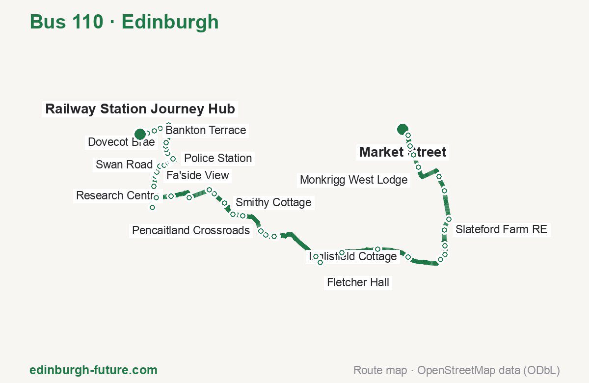
Route at a glance
| Mode | Bus |
|---|---|
| Route number | 110 |
| City | Edinburgh |
| Operator | Lothian Buses |
| Start → end | Market Street → Railway Station Journey Hub |
| End → start | Railway Station Journey Hub → Market Street |
| Route length | 39.7 km / 30.4 km in the opposite direction |
| Number of stops | 51 / 49 in the opposite direction |
| Travel time | about 47 minutes |
| Trips per day | 15 on weekdays one way |
| Frequency | peak 25–66 · midday 55–65 |
| First / last trip from «Market Street» | 06:40 / 18:50 |
| First / last trip from «Railway Station Journey Hub» | 07:28 / 19:05 |
| Fare | 2.40 £ (fare in effect since 22 February 2026) |
| Updated | August 22, 2026 |
Route of Bus 110
Outbound: Market Street → Railway Station Journey Hub
This direction has 51 stops and runs 39.7 km. The route passes St Mary’s Church, Bolton Muir Wood, Winton Terrace, King’s Road. Below is the full list with the distance from the first stop.
| No. | Stop | From start | Note |
|---|---|---|---|
| 1 | Market Street | 0.0 km | Terminus |
| 2 | St Mary’s Church | 0.5 km | |
| 3 | Lennoxlove Acredales | 1.1 km | |
| 4 | Lennoxlove East Port | 1.5 km | |
| 5 | Monkrigg West Lodge | 2.1 km | |
| 6 | Cockles Smiddy | 3.6 km | |
| 7 | Beech Hill RE | 4.3 km | |
| 8 | Myreside RE | 5.7 km | |
| 9 | Slateford Farm RE | 6.2 km | |
| 10 | Gifford Vale | 7.0 km | |
| 11 | Goblin Ha’ | 7.4 km | |
| 12 | Tweeddale Ave | 7.7 km | |
| 13 | Inglisfield Cottage | 9.4 km | |
| 14 | Bolton Muir Wood | 10.9 km | |
| 15 | Oak Cottage | 12.6 km | |
| 16 | Byre Court | 13.7 km | |
| 17 | Fletcher Hall | 14.0 km | |
| 18 | Car Park | 16.4 km | |
| 19 | Pencaitland Park Footpath | 16.4 km | |
| 20 | Vinefields | 16.9 km | |
| 21 | Pencaitland Crossroads | 17.1 km | |
| 22 | Oak Cottage | 12.6 km | |
| 23 | Wintonhill Road End | 27.5 km | |
| 24 | Winton Lodge | 28.0 km | |
| 25 | Smithy Cottage | 28.7 km | |
| 26 | Winton Terrace | 29.3 km | |
| 27 | Puddle Burn | 29.6 km | |
| 28 | Buxley Farm Road End | 30.6 km | |
| 29 | Research Centre | 31.7 km | |
| 30 | North Elphinstone | 32.4 km | |
| 31 | Duries Park | 33.1 km | |
| 32 | Research Centre RE | 34.1 km | |
| 33 | Fa’side View | 34.5 km | |
| 34 | Castle Road | 34.7 km | |
| 35 | West Windygoul | 34.7 km | |
| 36 | Fleets Road | 35.1 km | |
| 37 | Swan Road | 35.3 km | |
| 38 | King’s Road | 35.6 km | |
| 39 | Harkness Crescent | 35.7 km | |
| 40 | Health Centre | 35.9 km | |
| 41 | Police Station | 36.2 km | |
| 42 | Elder Court | 36.6 km | |
| 43 | Fire Station | 36.8 km | |
| 44 | Fowler Street | 37.0 km | |
| 45 | Dovecot Brae | 37.1 km | |
| 46 | Blindwells South | 38.0 km | |
| 47 | Meadowmill Roundabout | 38.2 km | |
| 48 | Johnny Cope Stone | 38.7 km | |
| 49 | Bankton Terrace | 39.0 km | |
| 50 | Polwarth Terrace | 39.3 km | |
| 51 | Railway Station Journey Hub | 39.7 km | Terminus |
Inbound: Railway Station Journey Hub → Market Street
This direction has 49 stops and runs 30.4 km. The route passes Polwarth Terrace, Harkness Crescent, Buxley Farm Road End, Oak Cottage. Below is the full list with the distance from the first stop.
| No. | Stop | From start | Note |
|---|---|---|---|
| 1 | Railway Station Journey Hub | 0.0 km | Terminus |
| 2 | Polwarth Terrace | 0.3 km | |
| 3 | Bankton Terrace | 0.7 km | |
| 4 | Johnny Cope Stone | 0.9 km | |
| 5 | Meadowmill Roundabout | 1.4 km | |
| 6 | Blindwells South | 1.8 km | |
| 7 | Dovecot Brae | 2.6 km | |
| 8 | Fowler Street | 2.8 km | |
| 9 | Parish Church | 3.0 km | |
| 10 | Elder Court | 3.2 km | |
| 11 | Police Station | 3.6 km | |
| 12 | Health Centre | 3.8 km | |
| 13 | Harkness Crescent | 4.0 km | |
| 14 | King’s Road | 4.2 km | |
| 15 | Swan Road | 4.4 km | |
| 16 | Fleets Road | 4.6 km | |
| 17 | West Windygoul | 4.9 km | |
| 18 | Castle Road | 5.0 km | |
| 19 | Fa’side View | 5.2 km | |
| 20 | Research Centre RE | 5.7 km | |
| 21 | Duries Park | 6.7 km | |
| 22 | North Elphinstone | 7.3 km | |
| 23 | Research Centre | 8.0 km | |
| 24 | Buxley Farm Road End | 9.1 km | |
| 25 | Puddle Burn | 10.1 km | |
| 26 | Winton Terrace | 10.4 km | |
| 27 | Smithy Cottage | 11.1 km | |
| 28 | Winton Lodge | 11.8 km | |
| 29 | Wintonhill Road End | 12.2 km | |
| 30 | Boggs Holdings Road End | 13.0 km | |
| 31 | Pencaitland Crossroads | 13.4 km | |
| 32 | Limekilns | 13.9 km | |
| 33 | Fletcher Hall | 16.5 km | |
| 34 | Byre Court | 16.9 km | |
| 35 | Oak Cottage | 18.0 km | |
| 36 | Bolton Muir Wood | 19.7 km | |
| 37 | Inglisfield Cottage | 21.2 km | |
| 38 | Tweeddale Ave | 22.8 km | |
| 39 | Goblin Ha’ | 23.2 km | |
| 40 | Gifford Vale | 23.6 km | |
| 41 | Slateford Farm RE | 24.4 km | |
| 42 | Myreside RE | 24.9 km | |
| 43 | Beech Hill RE | 26.3 km | |
| 44 | Cockles Smiddy | 27.0 km | |
| 45 | Monkrigg West Lodge | 28.5 km | |
| 46 | Lennoxlove East Port | 29.1 km | |
| 47 | Lennoxlove Acredales | 29.5 km | |
| 48 | St Mary’s Church | 30.1 km | |
| 49 | High Street | 30.4 km | Terminus |
Schedule and frequency
According to the official schedule from Lothian Buses, the route runs 15 trips in one direction on a weekday.
| Direction | Weekdays | Weekends and holidays |
|---|---|---|
| From «Market Street» | 06:40 — 18:50 | — — — |
| From «Railway Station Journey Hub» | 07:28 — 19:05 | — — — |
Frequency calculated from the departure table: in the morning peak buses run every 25–66 minutes, most often every 64; midday every 55–65 minutes; in the afternoon peak every 30–60.
Fare and payment
A single ride costs 2.40 £ — fare in effect since 22 February 2026. The same fare applies to Lothian buses in Edinburgh.
A single bus journey costs £2.40 and covers one journey only — it gives no transfer and is not valid on Edinburgh Trams. A City DAYticket is £6.00 and works on both bus and tram; contactless travel is capped at £5.70 a day.
Frequently asked questions
How much does a ride on bus 110 cost?
2.40 £ for a single ride — fare in effect since 22 February 2026.
When do the first and last trips run?
From Market Street the first is at 06:40 and the last at 18:50. From Railway Station Journey Hub they are 07:28 and 19:05.
How long does the trip from Market Street to Railway Station Journey Hub take?
About 47 minutes end to end — the median of full trips in the official schedule.
How many stops does the route have?
51 outbound and 49 inbound according to the official GTFS feed. The two lists do not match exactly.
Does bus 110 run on weekends?
Yes, the route runs every day, with a separate weekend schedule.
Every route number with its termini, operating hours and travel time is collected in the Edinburgh buses overview.
Data current as of August 22, 2026. Schedule and termini — Lothian Buses. Fares — Lothian Buses. Stop list, schedule and route geometry come from the official GTFS feed (Bus Open Data Service (BODS)).