

Bus N35 in Edinburgh links Ocean Terminal and Heriot Watt Campus. The route is 16.8 km long with 54 stops, and the official schedule from Lothian Buses puts the full trip at about 48 minutes. On a weekday it runs 2 trips in one direction.
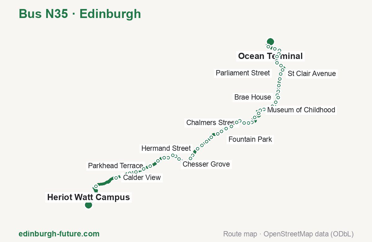
Route at a glance
| Mode | Bus |
|---|---|
| Route number | N35 |
| City | Edinburgh |
| Operator | Lothian Buses |
| Start → end | Ocean Terminal → Heriot Watt Campus |
| End → start | Heriot Watt Campus → Ocean Terminal |
| Route length | 16.8 km / 19.4 km in the opposite direction |
| Number of stops | 54 / 55 in the opposite direction |
| Travel time | about 48 minutes |
| Trips per day | 2 on weekdays one way |
| Frequency | — |
| First / last trip from «Ocean Terminal» | 00:00 / 01:02 |
| First / last trip from «Heriot Watt Campus» | 01:35 / 01:35 |
| Fare | 2.40 £ (fare in effect since 22 February 2026) |
| Updated | August 22, 2026 |
Route of Bus N35
Outbound: Ocean Terminal → Heriot Watt Campus
This direction has 54 stops and runs 16.8 km. The route passes Commercial Street, Abbeymount, East Fountainbridge, Chesser Grove. Below is the full list with the distance from the first stop.
| No. | Stop | From start | Note |
|---|---|---|---|
| 1 | Ocean Terminal | 0.0 km | Terminus |
| 2 | Commercial Street | 0.7 km | |
| 3 | Victoria Quay | 1.0 km | |
| 4 | Sandport Street | 1.3 km | |
| 5 | The Shore | 1.5 km | |
| 6 | Parliament Street | 1.7 km | |
| 7 | St Anthony Street | 1.9 km | |
| 8 | Kirkgate Centre | 2.0 km | |
| 9 | Duke Street | 2.3 km | |
| 10 | Academy Park | 2.5 km | |
| 11 | St Clair Avenue | 2.8 km | |
| 12 | Dalmeny Street | 3.0 km | |
| 13 | Brunswick Road | 3.3 km | |
| 14 | Montgomery Street | 3.6 km | |
| 15 | Abbeymount | 3.8 km | |
| 16 | Brae House | 4.0 km | |
| 17 | Abbeyhill Crescent | 4.2 km | |
| 18 | Scottish Parliament | 4.5 km | |
| 19 | Canongate Kirk | 4.7 km | |
| 20 | New Street | 4.9 km | |
| 21 | Museum of Childhood | 5.1 km | |
| 22 | South Bridge | 5.4 km | |
| 23 | National Museum of Scotland | 5.7 km | |
| 24 | Lauriston Place | 6.2 km | |
| 25 | Lauriston Building | 6.4 km | |
| 26 | Chalmers Street | 6.6 km | |
| 27 | Lauriston Street | 6.8 km | |
| 28 | East Fountainbridge | 7.0 km | |
| 29 | Port Hamilton | 7.3 km | |
| 30 | Gilmore Park | 7.6 km | |
| 31 | Fountain Park | 7.9 km | |
| 32 | Dundee Terrace | 8.1 km | |
| 33 | Angle Park Terrace | 8.5 km | |
| 34 | St Michaels Church | 8.8 km | |
| 35 | Shandon Place | 9.1 km | |
| 36 | Hermand Street | 9.4 km | |
| 37 | Hutchison Crossway | 9.8 km | |
| 38 | Hutchison Place | 10.0 km | |
| 39 | Slateford Station | 10.3 km | |
| 40 | Edinburgh West Retail Park | 10.8 km | |
| 41 | Chesser Grove | 11.0 km | |
| 42 | Chesser Avenue | 11.2 km | |
| 43 | Stenhouse Mill Lane | 11.4 km | |
| 44 | HMP Edinburgh | 11.7 km | |
| 45 | Saughton Mains Avenue | 12.0 km | |
| 46 | Parkhead Terrace | 12.5 km | |
| 47 | Sighthill Post office | 12.8 km | |
| 48 | Sighthill Gardens | 13.2 km | |
| 49 | Napier University (Sighthill) | 13.6 km | |
| 50 | Wester Hailes Road | 13.9 km | |
| 51 | Calder View | 14.3 km | |
| 52 | Hermiston Park & Ride | 15.4 km | |
| 53 | The Avenue | 16.5 km | |
| 54 | Heriot Watt Campus | 16.8 km | Terminus |
Inbound: Heriot Watt Campus → Ocean Terminal
This direction has 55 stops and runs 19.4 km. The route passes The Avenue, Slateford Station, Bread Street, Albert Street. Below is the full list with the distance from the first stop.
| No. | Stop | From start | Note |
|---|---|---|---|
| 1 | Heriot Watt Campus | 0.0 km | Terminus |
| 2 | The Avenue | 0.2 km | |
| 3 | Hermiston Park & Ride | 1.2 km | |
| 4 | Burtons Biscuits Factory | 2.5 km | |
| 5 | Napier University (Sighthill) | 2.9 km | |
| 6 | Sighthill Green | 3.3 km | |
| 7 | Broomhouse Road | 4.0 km | |
| 8 | Sighthill Post Office | 4.2 km | |
| 9 | Saughton Mains | 6.0 km | |
| 10 | Saughton Mains Avenue | 6.7 km | |
| 11 | HMP Edinburgh | 7.0 km | |
| 12 | Stenhouse Mill Lane | 7.2 km | |
| 13 | Chesser Grove | 7.7 km | |
| 14 | Edinburgh West Retail Park | 7.9 km | |
| 15 | Slateford Station | 8.4 km | |
| 16 | Hutchison Place | 8.6 km | |
| 17 | Hutchison Crossway | 8.8 km | |
| 18 | Moat Drive | 9.5 km | |
| 19 | Shandon Place | 10.0 km | |
| 20 | St Michaels Church | 10.2 km | |
| 21 | Angle Park Terrace | 10.9 km | |
| 22 | Dundee Terrace | 11.3 km | |
| 23 | Fountain Park | 11.6 km | |
| 24 | Gilmore Park | 11.9 km | |
| 25 | Grove Street | 12.1 km | |
| 26 | Port Hamilton | 12.2 km | |
| 27 | Semple Street | 12.5 km | |
| 28 | Bread Street | 12.7 km | |
| 29 | Glen Street | 13.0 km | |
| 30 | Lauriston Building | 13.4 km | |
| 31 | Forrest Road | 13.8 km | |
| 32 | National Museum of Scotland | 14.0 km | |
| 33 | South Bridge | 14.3 km | |
| 34 | Museum of Childhood | 14.6 km | |
| 35 | Canongate Kirk | 15.0 km | |
| 36 | Scottish Parliament | 15.3 km | |
| 37 | Abbeyhill Crescent | 15.5 km | |
| 38 | Abbeymount | 15.8 km | |
| 39 | Montgomery Street | 16.0 km | |
| 40 | Brunswick Road | 16.3 km | |
| 41 | Albert Street | 16.6 km | |
| 42 | Dalmeny Street | 16.7 km | |
| 43 | St Clair Avenue | 16.9 km | |
| 44 | Academy Park | 17.1 km | |
| 45 | Duke Street | 17.3 km | |
| 46 | Academy Street | 17.5 km | |
| 47 | Kirkgate Centre | 17.7 km | |
| 48 | St Anthony Street | 17.9 km | |
| 49 | Parliament Street | 18.1 km | |
| 50 | The Shore | 18.3 km | |
| 51 | Sandport Street | 18.6 km | |
| 52 | Victoria Quay | 18.8 km | |
| 53 | Commercial Street | 19.0 km | |
| 54 | Ocean Drive | 19.2 km | |
| 55 | Ocean Terminal | 19.4 km | Terminus |
Schedule and frequency
According to the official schedule from Lothian Buses, the route runs 2 trips in one direction on a weekday.
| Direction | Weekdays | Weekends and holidays |
|---|---|---|
| From «Ocean Terminal» | 00:00 — 01:02 | — — — |
| From «Heriot Watt Campus» | 01:35 — 01:35 | 00:33 — 01:35 |
Fare and payment
A single ride costs 2.40 £ — fare in effect since 22 February 2026. The same fare applies to Lothian buses in Edinburgh.
A single bus journey costs £2.40 and covers one journey only — it gives no transfer and is not valid on Edinburgh Trams. A City DAYticket is £6.00 and works on both bus and tram; contactless travel is capped at £5.70 a day.
Frequently asked questions
How much does a ride on bus N35 cost?
2.40 £ for a single ride — fare in effect since 22 February 2026.
When do the first and last trips run?
From Ocean Terminal the first is at 00:00 and the last at 01:02. From Heriot Watt Campus they are 01:35 and 01:35.
How long does the trip from Ocean Terminal to Heriot Watt Campus take?
About 48 minutes end to end — the median of full trips in the official schedule.
How many stops does the route have?
54 outbound and 55 inbound according to the official GTFS feed. The two lists do not match exactly.
Does bus N35 run on weekends?
Yes, the route runs every day, with a separate weekend schedule.
Every route number with its termini, operating hours and travel time is collected in the Edinburgh buses overview.
Data current as of August 22, 2026. Schedule and termini — Lothian Buses. Fares — Lothian Buses. Stop list, schedule and route geometry come from the official GTFS feed (Bus Open Data Service (BODS)).