

Bus 111 in Edinburgh links High Street and Royal Infirmary. The route is 43.4 km long with 91 stops, and the official schedule from Lothian Buses puts the full trip at about 85 minutes. On a weekday it runs 10 trips in one direction.
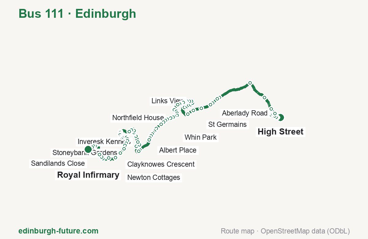
Route at a glance
| Mode | Bus |
|---|---|
| Route number | 111 |
| City | Edinburgh |
| Operator | Lothian Buses |
| Start → end | High Street → Royal Infirmary |
| End → start | Royal Infirmary → High Street |
| Route length | 43.4 km / 43.3 km in the opposite direction |
| Number of stops | 91 / 90 in the opposite direction |
| Travel time | about 85 minutes |
| Trips per day | 10 on weekdays one way |
| Frequency | peak 60–105 · midday 45–95 |
| First / last trip from «High Street» | 06:05 / 17:05 |
| First / last trip from «Royal Infirmary» | 07:30 / 18:35 |
| Fare | 2.40 £ (fare in effect since 22 February 2026) |
| Updated | August 22, 2026 |
Route of Bus 111
Outbound: High Street → Royal Infirmary
This direction has 91 stops and runs 43.4 km. The route passes Police Station, Forth Wynd, Auction House, Clayknowes Avenue. Below is the full list with the distance from the first stop.
| No. | Stop | From start | Note |
|---|---|---|---|
| 1 | High Street | 0.0 km | Terminus |
| 2 | Police Station | 0.4 km | |
| 3 | Station Road | 0.5 km | |
| 4 | Caponflat Crescent | 0.8 km | |
| 5 | East Lothian Community Hospital | 1.3 km | |
| 6 | Alderston Place | 1.4 km | |
| 7 | Davidson Terrace | 1.6 km | |
| 8 | Hawthornbank Road | 1.8 km | |
| 9 | Aberlady Road | 2.0 km | |
| 10 | Harperdean | 2.7 km | |
| 11 | West Garleton | 4.2 km | |
| 12 | Ballencrieff Roundabout | 6.7 km | |
| 13 | Railway Station | 10.7 km | |
| 14 | Longniddry Inn | 11.0 km | |
| 15 | Cunningham Court | 11.7 km | |
| 16 | Dean Road | 12.0 km | |
| 17 | St Germains | 13.2 km | |
| 18 | Seton East | 14.1 km | |
| 19 | Seton West Mains | 14.9 km | |
| 20 | Rowanhill Drive | 16.4 km | |
| 21 | Sycamore Avenue | 16.7 km | |
| 22 | Poplar Park | 16.9 km | |
| 23 | Seton Wynd | 17.2 km | |
| 24 | Forth Wynd | 17.5 km | |
| 25 | Links View | 17.8 km | |
| 26 | Castle Terrace | 18.0 km | |
| 27 | Fishers Road | 18.3 km | |
| 28 | Park Road | 18.5 km | |
| 29 | Cope Lane | 18.7 km | |
| 30 | Inglis Avenue | 18.8 km | |
| 31 | School Lane | 19.1 km | |
| 32 | East Lorimer Place | 19.2 km | |
| 33 | Whin Park | 19.4 km | |
| 34 | Preston Links (West) | 20.2 km | |
| 35 | Atholl View | 20.4 km | |
| 36 | McLachlan Gardens | 20.7 km | |
| 37 | Preston Lodge | 20.9 km | |
| 38 | Hawthorn Road | 21.2 km | |
| 39 | Polwarth Terrace | 21.5 km | |
| 40 | Health Centre | 21.7 km | |
| 41 | Northfield House | 22.1 km | |
| 42 | Alexander Drive | 22.5 km | |
| 43 | Drummore Drive | 22.7 km | |
| 44 | Rowberry Walk | 23.0 km | |
| 45 | Moodie Wynd | 23.4 km | |
| 46 | Auction House | 24.2 km | |
| 47 | Chuckers Row | 24.6 km | |
| 48 | Miners Welfare | 24.8 km | |
| 49 | Albert Place | 25.0 km | |
| 50 | Fa’side Avenue | 25.2 km | |
| 51 | Park Drive | 25.5 km | |
| 52 | St Clements Wells | 25.8 km | |
| 53 | Whitecraig Avenue | 27.4 km | |
| 54 | Whitecraig Crescent | 27.6 km | |
| 55 | Cowpits | 28.6 km | |
| 56 | Carberry Road | 29.2 km | |
| 57 | Inveresk Kennels | 29.5 km | |
| 58 | Inveresk Village | 30.2 km | |
| 59 | Musselburgh Grammar School | 30.7 km | |
| 60 | Rothesay Place | 30.8 km | |
| 61 | Newbigging | 31.1 km | |
| 62 | High Street (Stop D) | 31.6 km | |
| 63 | Tesco Terminus | 32.0 km | |
| 64 | Mall Avenue | 32.1 km | |
| 65 | Clayknowes Crescent | 33.3 km | |
| 66 | Stoneyhill Drive | 33.4 km | |
| 67 | Clayknowes Place | 33.6 km | |
| 68 | Clayknowes Avenue | 33.7 km | |
| 69 | Clayknowes Court | 34.0 km | |
| 70 | Denholm Drive | 34.1 km | |
| 71 | Whitehill Gardens | 34.3 km | |
| 72 | Whitehill Avenue | 34.4 km | |
| 73 | Stoneybank Gardens | 34.6 km | |
| 74 | Haugh Park | 34.9 km | |
| 75 | Stoneybank Place | 35.0 km | |
| 76 | Mayfield Crescent | 35.2 km | |
| 77 | Musselburgh Golf Club | 35.5 km | |
| 78 | Craighall Drive | 35.8 km | |
| 79 | Old Craighall Services | 36.1 km | |
| 80 | Old Craighall | 36.5 km | |
| 81 | Newton Cottages | 37.1 km | |
| 82 | Easter Millerhill | 38.0 km | |
| 83 | Newton Church Road | 39.0 km | |
| 84 | Newton Church Road | 39.7 km | |
| 85 | Edmonstone Road | 40.0 km | |
| 86 | Edmonstone Avenue | 40.4 km | |
| 87 | Bowes Place | 42.0 km | |
| 88 | Milligan Drive | 42.2 km | |
| 89 | Sandilands Close | 42.5 km | |
| 90 | SCRM | 42.9 km | |
| 91 | Royal Infirmary | 43.4 km | Terminus |
Inbound: Royal Infirmary → High Street
This direction has 90 stops and runs 43.3 km. The route passes SCRM, Denholm Drive, Miners Welfare, Castle Terrace. Below is the full list with the distance from the first stop.
| No. | Stop | From start | Note |
|---|---|---|---|
| 1 | Royal Infirmary | 0.0 km | Terminus |
| 2 | SCRM | 0.6 km | |
| 3 | Sandilands Close | 1.0 km | |
| 4 | Milligan Drive | 1.3 km | |
| 5 | Bowes Place | 1.5 km | |
| 6 | Edmonstone Road | 2.9 km | |
| 7 | Edmonstone Avenue | 3.1 km | |
| 8 | Edmonstone Road | 3.5 km | |
| 9 | Edmonstone Drive | 3.6 km | |
| 10 | Newton Church Road | 3.8 km | |
| 11 | Millerhill Road | 4.5 km | |
| 12 | Easter Millerhill | 5.5 km | |
| 13 | Newton Cottages | 6.3 km | |
| 14 | Main Road | 6.9 km | |
| 15 | Old Craighall Services | 7.3 km | |
| 16 | Craighall Drive | 7.5 km | |
| 17 | Golf Club | 7.9 km | |
| 18 | Mayfield Crescent | 8.2 km | |
| 19 | Stoneybank Place | 8.3 km | |
| 20 | Haugh Park | 8.6 km | |
| 21 | Stoneybank Gardens | 8.8 km | |
| 22 | Whitehill Avenue | 8.9 km | |
| 23 | Whitehill Gardens | 9.1 km | |
| 24 | Denholm Drive | 9.3 km | |
| 25 | Clayknowes Court | 9.5 km | |
| 26 | Clayknowes Avenue | 9.7 km | |
| 27 | Stoneyhill Drive | 10.1 km | |
| 28 | Clayknowes Crescent | 10.2 km | |
| 29 | Olive Bank Road | 10.6 km | |
| 30 | Mall Avenue | 11.3 km | |
| 31 | Tesco Terminus | 11.5 km | |
| 32 | High Street (Stop A) | 11.9 km | |
| 33 | Newbigging | 12.3 km | |
| 34 | Rothesay Place | 12.7 km | |
| 35 | Musselburgh Grammar School | 12.8 km | |
| 36 | Inveresk Village | 13.2 km | |
| 37 | Inveresk Kennels | 13.9 km | |
| 38 | Carberry Road | 14.3 km | |
| 39 | Cowpits | 14.9 km | |
| 40 | Whitecraig Crescent | 15.8 km | |
| 41 | Whitecraig Avenue | 16.0 km | |
| 42 | St Clements Wells | 17.7 km | |
| 43 | Park Drive | 18.0 km | |
| 44 | Drummohr Avenue | 18.2 km | |
| 45 | Albert Place | 18.5 km | |
| 46 | Miners Welfare | 18.6 km | |
| 47 | Chuckers Row | 18.9 km | |
| 48 | Auction House | 19.2 km | |
| 49 | Moodie Wynd | 19.8 km | |
| 50 | Rowberry Walk | 20.4 km | |
| 51 | Drummore Drive | 20.6 km | |
| 52 | Alexander Drive | 20.9 km | |
| 53 | Northfield House | 21.3 km | |
| 54 | Health Centre | 21.7 km | |
| 55 | Polwarth Terrace | 21.9 km | |
| 56 | Hawthorn Road | 22.1 km | |
| 57 | Preston Lodge | 22.4 km | |
| 58 | McLachlan Gardens | 22.7 km | |
| 59 | Atholl View | 22.9 km | |
| 60 | Preston Links | 23.2 km | |
| 61 | Whin Park | 23.9 km | |
| 62 | East Lorimer Place | 24.2 km | |
| 63 | School Lane | 24.4 km | |
| 64 | Inglis Avenue | 24.6 km | |
| 65 | Cope Lane | 24.7 km | |
| 66 | Park Road | 24.9 km | |
| 67 | Fishers Road | 25.1 km | |
| 68 | Castle Terrace | 25.4 km | |
| 69 | Links View | 25.6 km | |
| 70 | Forth Wynd | 25.8 km | |
| 71 | Seton Wynd | 26.2 km | |
| 72 | Poplar Park | 26.5 km | |
| 73 | Sycamore Avenue | 26.8 km | |
| 74 | Rowanhill Drive | 27.1 km | |
| 75 | Seton West Mains | 28.4 km | |
| 76 | Seton East | 29.2 km | |
| 77 | St Germains | 30.4 km | |
| 78 | Dean Road | 31.4 km | |
| 79 | Cunningham Court | 31.6 km | |
| 80 | Longniddry Inn | 32.3 km | |
| 81 | Railway Station | 32.6 km | |
| 82 | Ballencrieff Roundabout | 36.6 km | |
| 83 | West Garleton | 39.2 km | |
| 84 | Harperdean | 40.7 km | |
| 85 | Aberlady Road | 41.4 km | |
| 86 | Davidson Terrace | 41.7 km | |
| 87 | East Lothian Community Hospital | 42.1 km | |
| 88 | Caponflat Crescent | 42.6 km | |
| 89 | Station Road | 42.9 km | |
| 90 | Market Street | 43.3 km | Terminus |
Schedule and frequency
According to the official schedule from Lothian Buses, the route runs 10 trips in one direction on a weekday.
| Direction | Weekdays | Weekends and holidays |
|---|---|---|
| From «High Street» | 06:05 — 17:05 | — — — |
| From «Royal Infirmary» | 07:30 — 18:35 | — — — |
Frequency calculated from the departure table: in the morning peak buses run every 60–105 minutes, most often every 82; midday every 45–95 minutes.
Fare and payment
A single ride costs 2.40 £ — fare in effect since 22 February 2026. The same fare applies to Lothian buses in Edinburgh.
A single bus journey costs £2.40 and covers one journey only — it gives no transfer and is not valid on Edinburgh Trams. A City DAYticket is £6.00 and works on both bus and tram; contactless travel is capped at £5.70 a day.
Frequently asked questions
How much does a ride on bus 111 cost?
2.40 £ for a single ride — fare in effect since 22 February 2026.
When do the first and last trips run?
From High Street the first is at 06:05 and the last at 17:05. From Royal Infirmary they are 07:30 and 18:35.
How long does the trip from High Street to Royal Infirmary take?
About 85 minutes end to end — the median of full trips in the official schedule.
How many stops does the route have?
91 outbound and 90 inbound according to the official GTFS feed. The two lists do not match exactly.
Does bus 111 run on weekends?
Yes, the route runs every day, with a separate weekend schedule.
Every route number with its termini, operating hours and travel time is collected in the Edinburgh buses overview.
Data current as of August 22, 2026. Schedule and termini — Lothian Buses. Fares — Lothian Buses. Stop list, schedule and route geometry come from the official GTFS feed (Bus Open Data Service (BODS)).