

Bus N43 in Edinburgh links Leith Street and Royston Roundabout. The route is 39.5 km long with 94 stops, and the official schedule from Lothian Buses puts the full trip at about 73 minutes. On a weekday it runs 1 trip in one direction, and 2 on a weekend day.
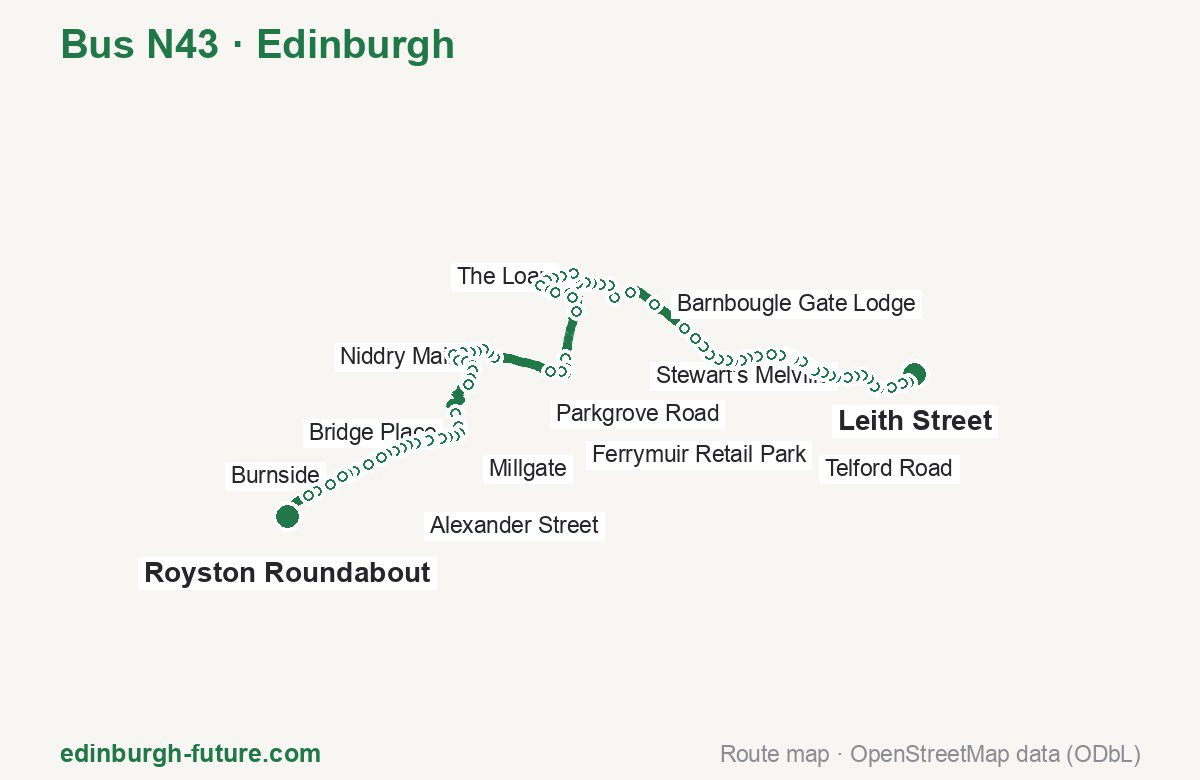
Route at a glance
| Mode | Bus |
|---|---|
| Route number | N43 |
| City | Edinburgh |
| Operator | Lothian Buses |
| Start → end | Leith Street → Royston Roundabout |
| End → start | Royston Roundabout → Leith Street |
| Route length | 39.5 km / 26.7 km in the opposite direction |
| Number of stops | 94 / 58 in the opposite direction |
| Travel time | about 73 minutes |
| Trips per day | 1 on weekdays, 2 on weekends one way |
| Frequency | — |
| First / last trip from «Leith Street» | 00:30 / 00:30 |
| First / last trip from «Royston Roundabout» | None / None |
| Fare | 2.40 £ (fare in effect since 22 February 2026) |
| Updated | August 22, 2026 |
Route of Bus N43
Outbound: Leith Street → Royston Roundabout
This direction has 94 stops and runs 39.5 km. The route passes Princes Street (Waverley Steps), Parkgrove Road, Long Crook, Aldi. Below is the full list with the distance from the first stop.
| No. | Stop | From start | Note |
|---|---|---|---|
| 1 | Leith Street | 0.0 km | Terminus |
| 2 | Princes Street (Waverley Steps) | 0.4 km | |
| 3 | Princes Street (Scott Mon.) | 0.7 km | |
| 4 | Princes Street (west) | 1.1 km | |
| 5 | Queensferry Street | 1.7 km | |
| 6 | Drumsheugh Place | 1.9 km | |
| 7 | Dean Bridge | 2.3 km | |
| 8 | Learmonth Terrace | 2.6 km | |
| 9 | Stewart’s Melville | 2.9 km | |
| 10 | Queensferry Terrace | 3.1 km | |
| 11 | Orchard Road | 3.6 km | |
| 12 | Craigleith Drive | 3.8 km | |
| 13 | Craigleith Road | 4.1 km | |
| 14 | Maidencraig Crescent | 4.5 km | |
| 15 | St Columba’s Church | 4.8 km | |
| 16 | Columba Avenue | 4.9 km | |
| 17 | Telford Road | 5.1 km | |
| 18 | Blackhall Library | 5.4 km | |
| 19 | Marchfield Terrace | 5.6 km | |
| 20 | Marchfield Park | 5.8 km | |
| 21 | Marchfield Park Lane | 6.0 km | |
| 22 | Hillpark Steps | 6.3 km | |
| 23 | Clermiston Drive | 6.8 km | |
| 24 | Parkgrove Street | 7.2 km | |
| 25 | Parkgrove Road | 7.5 km | |
| 26 | Drum Brae North | 7.9 km | |
| 27 | Barnton Junction | 8.1 km | |
| 28 | Cammo Crescent | 8.4 km | |
| 29 | Braehead Avenue | 8.8 km | |
| 30 | Cramond Bridge | 9.2 km | |
| 31 | Craigiehall | 9.6 km | |
| 32 | Burnshot Flyover | 10.2 km | |
| 33 | Barnbougle Gate Lodge | 11.7 km | |
| 34 | Easter Dalmeny | 12.8 km | |
| 35 | Village Hall | 13.5 km | |
| 36 | Bankhead Cottages | 14.0 km | |
| 37 | Railway Station | 14.4 km | |
| 38 | Ashburnham Road | 14.7 km | |
| 39 | Queen Margaret Drive | 14.9 km | |
| 40 | Burgess Road | 15.3 km | |
| 41 | The Loan | 15.6 km | |
| 42 | Queensferry Police Station | 15.8 km | |
| 43 | Walker Drive | 16.3 km | |
| 44 | Springfield View | 16.6 km | |
| 45 | Springfield Crescent | 16.9 km | |
| 46 | Echline Corner | 17.2 km | |
| 47 | Echline Park | 17.8 km | |
| 48 | Long Crook | 18.0 km | |
| 49 | Ferrymuir Retail Park | 18.8 km | |
| 50 | Ferrymuir Retail Park | 19.0 km | |
| 51 | Dundas Castle | 19.9 km | |
| 52 | Eilston Road | 21.8 km | |
| 53 | Community Centre | 22.2 km | |
| 54 | Station Road | 22.4 km | |
| 55 | Manse Road | 22.6 km | |
| 56 | Stirling Road | 23.0 km | |
| 57 | Niddry Mains | 25.3 km | |
| 58 | Broomhouse Drive | 25.6 km | |
| 59 | Violet Wynd | 25.9 km | |
| 60 | Station View | 26.2 km | |
| 61 | Clay Pit Pond | 26.4 km | |
| 62 | Sainsbury’s | 26.7 km | |
| 63 | Lamond Crescent | 27.1 km | |
| 64 | Tippetknowes Estate | 27.8 km | |
| 65 | Millgate | 28.1 km | |
| 66 | Health Centre | 28.4 km | |
| 67 | Craigton Place | 28.6 km | |
| 68 | Glass Road | 29.0 km | |
| 69 | Niddry Cottages | 29.3 km | |
| 70 | Greendykes Steadings | 30.9 km | |
| 71 | Aldi | 31.4 km | |
| 72 | Albyn Place | 31.4 km | |
| 73 | Bridge Place | 31.7 km | |
| 74 | Post Office | 32.0 km | |
| 75 | New Holygate | 32.3 km | |
| 76 | Kirkhill Road | 32.5 km | |
| 77 | Cardross Road | 32.9 km | |
| 78 | Cardross Road | 33.0 km | |
| 79 | Freeland Avenue | 33.4 km | |
| 80 | Cemetery | 33.5 km | |
| 81 | Alexander Street | 33.8 km | |
| 82 | Oatridge Hotel | 34.1 km | |
| 83 | St Andrews Drive | 34.4 km | |
| 84 | Houstoun House Hotel | 34.7 km | |
| 85 | Golf Club | 35.0 km | |
| 86 | Riding School | 35.5 km | |
| 87 | Badger Wood | 36.1 km | |
| 88 | Knightsridge Road | 36.4 km | |
| 89 | Burnside | 36.7 km | |
| 90 | Bangour Hospital Main Gate | 37.2 km | |
| 91 | Bangour Farm Road End | 37.9 km | |
| 92 | Bents Cottages | 38.2 km | |
| 93 | Royston Hall | 39.3 km | |
| 94 | Royston Roundabout | 39.5 km | Terminus |
Inbound: Royston Roundabout → Leith Street
This direction has 58 stops and runs 26.7 km. The route passes Station Road, Springfield Crescent, Craigiehall, Columba Avenue. Below is the full list with the distance from the first stop.
| No. | Stop | From start | Note |
|---|---|---|---|
| 1 | Millgate | 0.0 km | Terminus |
| 2 | Station Road | 0.4 km | |
| 3 | School | 0.5 km | |
| 4 | Niddry Mains | 1.3 km | |
| 5 | Stirling Road | 3.5 km | |
| 6 | Manse Road | 4.0 km | |
| 7 | Station Road | 4.1 km | |
| 8 | Community Centre | 4.4 km | |
| 9 | Eilston Road | 4.7 km | |
| 10 | Dundas Castle | 6.6 km | |
| 11 | Ferrymuir Retail Park | 7.4 km | |
| 12 | Ferrymuir Retail Park | 7.6 km | |
| 13 | Long Crook | 8.4 km | |
| 14 | Echline Park | 8.6 km | |
| 15 | Echline Corner | 9.2 km | |
| 16 | Springfield Crescent | 9.6 km | |
| 17 | Springfield View | 9.9 km | |
| 18 | Walker Drive | 10.2 km | |
| 19 | Queensferry Police Station | 10.6 km | |
| 20 | The Loan | 10.8 km | |
| 21 | Burgess Road | 11.2 km | |
| 22 | Queen Margaret Drive | 11.5 km | |
| 23 | Ashburnham Road | 11.7 km | |
| 24 | Railway Station | 12.1 km | |
| 25 | Bankhead Cottages | 12.5 km | |
| 26 | Village Hall | 12.9 km | |
| 27 | Easter Dalmeny | 13.8 km | |
| 28 | Barnbougle Gate Lodge | 14.7 km | |
| 29 | Burnshot Flyover | 16.3 km | |
| 30 | Craigiehall | 16.9 km | |
| 31 | Cramond Brig | 17.2 km | |
| 32 | Braehead Avenue | 17.7 km | |
| 33 | Cammo Crescent | 18.1 km | |
| 34 | Barnton Junction | 18.3 km | |
| 35 | Drum Brae North | 18.7 km | |
| 36 | Parkgrove Road | 18.9 km | |
| 37 | Parkgrove Street | 19.3 km | |
| 38 | Clermiston Drive | 19.7 km | |
| 39 | Hillpark Steps | 20.2 km | |
| 40 | Marchfield Park Lane | 20.5 km | |
| 41 | Marchfield Park | 20.7 km | |
| 42 | Blackhall Library | 21.0 km | |
| 43 | Telford Road | 21.4 km | |
| 44 | Columba Avenue | 21.6 km | |
| 45 | St Columba’s Church | 21.9 km | |
| 46 | Maidencraig Crescent | 22.0 km | |
| 47 | Craigleith Road | 22.4 km | |
| 48 | Craigleith Drive | 22.6 km | |
| 49 | Orchard Road | 23.1 km | |
| 50 | Queensferry Terrace | 23.3 km | |
| 51 | Stewart’s Melville | 23.5 km | |
| 52 | Learmonth Terrace | 23.9 km | |
| 53 | Dean Bridge | 24.2 km | |
| 54 | Drumsheugh Place | 24.6 km | |
| 55 | Queensferry Street | 24.9 km | |
| 56 | Princes Street (west) | 25.4 km | |
| 57 | Princes Street (Waverley Steps) | 26.1 km | |
| 58 | Leith Street | 26.7 km | Terminus |
Schedule and frequency
According to the official schedule from Lothian Buses, the route runs 1 trip in one direction on a weekday, and 2 on a weekend day.
| Direction | Weekdays | Weekends and holidays |
|---|---|---|
| From «Leith Street» | 00:30 — 00:30 | 00:30 — 02:45 |
| From «Royston Roundabout» | None — None | 01:35 — 01:35 |
Fare and payment
A single ride costs 2.40 £ — fare in effect since 22 February 2026. The same fare applies to Lothian buses in Edinburgh.
A single bus journey costs £2.40 and covers one journey only — it gives no transfer and is not valid on Edinburgh Trams. A City DAYticket is £6.00 and works on both bus and tram; contactless travel is capped at £5.70 a day.
Frequently asked questions
How much does a ride on bus N43 cost?
2.40 £ for a single ride — fare in effect since 22 February 2026.
When do the first and last trips run?
From Leith Street the first is at 00:30 and the last at 00:30. From Royston Roundabout they are None and None.
How long does the trip from Leith Street to Royston Roundabout take?
About 73 minutes end to end — the median of full trips in the official schedule.
How many stops does the route have?
94 outbound and 58 inbound according to the official GTFS feed. The two lists do not match exactly.
Does bus N43 run on weekends?
Yes. On weekends and holidays there are 2 trips in one direction, running from Leith Street between 00:30 and 02:45.
Every route number with its termini, operating hours and travel time is collected in the Edinburgh buses overview.
Data current as of August 22, 2026. Schedule and termini — Lothian Buses. Fares — Lothian Buses. Stop list, schedule and route geometry come from the official GTFS feed (Bus Open Data Service (BODS)).