

Bus 106 in Edinburgh links High Street and Western General Hospital. The route is 34.6 km long with 73 stops, and the official schedule from Lothian Buses puts the full trip at about 96 minutes. On a weekday it runs 19 trips in one direction, and 15 on a weekend day.
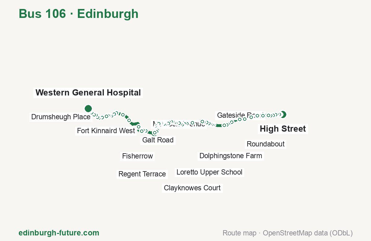
Route at a glance
| Mode | Bus |
|---|---|
| Route number | 106 |
| City | Edinburgh |
| Operator | Lothian Buses |
| Start → end | High Street → Western General Hospital |
| End → start | Western General Hospital → High Street |
| Route length | 34.6 km / 34.7 km in the opposite direction |
| Number of stops | 73 / 74 in the opposite direction |
| Travel time | about 96 minutes |
| Trips per day | 19 on weekdays, 15 on weekends one way |
| Frequency | peak 60 · midday 60 · weekend 25–83 |
| First / last trip from «High Street» | 06:17 / 22:08 |
| First / last trip from «Western General Hospital» | 05:24 / 22:16 |
| Fare | 2.40 £ (fare in effect since 22 February 2026) |
| Updated | August 22, 2026 |
Route of Bus 106
Outbound: High Street → Western General Hospital
This direction has 73 stops and runs 34.6 km. The route passes Police Station, Morrison Avenue, Beulah, Fort Kinnaird East. Below is the full list with the distance from the first stop.
| No. | Stop | From start | Note |
|---|---|---|---|
| 1 | High Street | 0.0 km | Terminus |
| 2 | Police Station | 0.4 km | |
| 3 | Station Road | 0.5 km | |
| 4 | Letham Drive | 0.9 km | |
| 5 | Park Lane | 1.1 km | |
| 6 | Knowes Road | 1.4 km | |
| 7 | Gateside Road | 1.8 km | |
| 8 | Arthurs Way | 2.1 km | |
| 9 | Letham Mains Rd End | 3.0 km | |
| 10 | Coates Road | 3.8 km | |
| 11 | Liberty Hall | 4.7 km | |
| 12 | Gladsmuir Farmhouse | 5.7 km | |
| 13 | Roundabout | 6.5 km | |
| 14 | Penston Road End | 7.7 km | |
| 15 | St Germains Terrace | 8.3 km | |
| 16 | Whiteloch Road | 8.6 km | |
| 17 | The Christies | 8.9 km | |
| 18 | Muirpark Road | 10.5 km | |
| 19 | Morrison Avenue | 10.8 km | |
| 20 | St Martin’s School | 11.0 km | |
| 21 | Police Station | 11.2 km | |
| 22 | Bridge Street | 11.6 km | |
| 23 | Polson Park | 12.0 km | |
| 24 | Polson Gardens | 12.3 km | |
| 25 | Dolphingstone Farm | 13.7 km | |
| 26 | Kinwegar Recycling Centre | 14.6 km | |
| 27 | Strawberry Corner | 14.9 km | |
| 28 | Chuckers Row | 15.2 km | |
| 29 | Railway Station | 15.3 km | |
| 30 | Wallyford Journey Hub | 15.5 km | |
| 31 | Galt Road | 15.7 km | |
| 32 | Moir Crescent | 16.0 km | |
| 33 | Levenhall Roundabout | 16.5 km | |
| 34 | Windsor Park Drive | 16.7 km | |
| 35 | Ashgrove North | 16.9 km | |
| 36 | Beulah | 17.2 km | |
| 37 | Loretto Upper School | 17.5 km | |
| 38 | St Peter’s Church | 17.7 km | |
| 39 | High Street (Stop D) | 18.1 km | |
| 40 | Bridge Street | 18.4 km | |
| 41 | Brunton Theatre Journey Hub | 18.7 km | |
| 42 | North High Street | 18.9 km | |
| 43 | Fisherrow | 19.1 km | |
| 44 | Harbour Point | 19.2 km | |
| 45 | Clayknowes Crescent | 19.7 km | |
| 46 | Stoneyhill Drive | 19.8 km | |
| 47 | Clayknowes Place | 20.0 km | |
| 48 | Clayknowes Avenue | 20.2 km | |
| 49 | Clayknowes Court | 20.4 km | |
| 50 | Denholm Drive | 20.6 km | |
| 51 | Queen Margaret University | 20.9 km | |
| 52 | Queen Margaret Drive | 21.2 km | |
| 53 | Fort Kinnaird East | 23.2 km | |
| 54 | Fort Kinnaird | 23.6 km | |
| 55 | Fort Kinnaird West | 24.1 km | |
| 56 | The Jewel | 25.1 km | |
| 57 | Paisley Drive | 27.1 km | |
| 58 | Meadowbank House | 28.4 km | |
| 59 | Abbeyhill | 29.4 km | |
| 60 | Calton Terrace Brae | 29.8 km | |
| 61 | Regent Terrace | 30.3 km | |
| 62 | St Andrew’s House | 30.6 km | |
| 63 | Waterloo Place | 30.8 km | |
| 64 | Princes Street (Waverley Steps) | 31.1 km | |
| 65 | Princes Street (west) | 31.8 km | |
| 66 | Queensferry Street | 32.3 km | |
| 67 | Drumsheugh Place | 32.5 km | |
| 68 | Dean Bridge | 32.9 km | |
| 69 | Learmonth Terrace | 33.2 km | |
| 70 | Flora Stevenson School | 33.7 km | |
| 71 | Comely Bank Cemetery | 34.0 km | |
| 72 | Western General | 34.3 km | |
| 73 | Western General Hospital | 34.6 km | Terminus |
Inbound: Western General Hospital → High Street
This direction has 74 stops and runs 34.7 km. The route passes Western General, Fort Kinnaird, Windsor Park Drive, Whiteloch Road. Below is the full list with the distance from the first stop.
| No. | Stop | From start | Note |
|---|---|---|---|
| 1 | Western General Hospital | 0.0 km | Terminus |
| 2 | Western General | 0.4 km | |
| 3 | Comely Bank Cemetery | 0.6 km | |
| 4 | Flora Stevenson School | 0.9 km | |
| 5 | Orchard Brae Avenue | 1.1 km | |
| 6 | Learmonth Terrace | 1.5 km | |
| 7 | Dean Bridge | 1.7 km | |
| 8 | Drumsheugh Place | 2.2 km | |
| 9 | Queensferry Street | 2.4 km | |
| 10 | Princes Street (west) | 2.9 km | |
| 11 | Waterloo Place | 3.8 km | |
| 12 | St Andrew’s House | 4.0 km | |
| 13 | Regent Terrace | 4.3 km | |
| 14 | Calton Terrace Brae | 4.8 km | |
| 15 | Abbeyhill | 5.2 km | |
| 16 | Meadowbank House | 6.2 km | |
| 17 | Paisley Drive | 7.5 km | |
| 18 | The Jewel | 9.6 km | |
| 19 | Fort Kinnaird West | 10.6 km | |
| 20 | Fort Kinnaird | 11.0 km | |
| 21 | Fort Kinnaird East | 11.6 km | |
| 22 | Queen Margaret Drive | 13.2 km | |
| 23 | Queen Margaret University | 13.5 km | |
| 24 | Denholm Drive | 13.8 km | |
| 25 | Clayknowes Court | 13.9 km | |
| 26 | Clayknowes Avenue | 14.2 km | |
| 27 | Stoneyhill Drive | 14.5 km | |
| 28 | Clayknowes Crescent | 14.7 km | |
| 29 | Harbour Point | 15.1 km | |
| 30 | Fisherow | 15.3 km | |
| 31 | Brunton Theatre Journey Hub | 15.7 km | |
| 32 | Bridge Street | 15.9 km | |
| 33 | High Street (Stop B) | 16.3 km | |
| 34 | St Peter’s Church | 16.6 km | |
| 35 | Loretto Upper School | 16.8 km | |
| 36 | Beulah | 17.1 km | |
| 37 | Ashgrove North | 17.5 km | |
| 38 | Windsor Park Drive | 17.7 km | |
| 39 | Levenhall Roundabout | 18.0 km | |
| 40 | Moir Crescent | 18.3 km | |
| 41 | Galt Road | 18.6 km | |
| 42 | Wallyford Journey Hub | 18.8 km | |
| 43 | Railway Station | 19.0 km | |
| 44 | Chuckers Row | 19.2 km | |
| 45 | Strawberry Corner | 19.4 km | |
| 46 | Kinwegar Recycling Centre | 19.7 km | |
| 47 | Dolphingstone Farm | 20.6 km | |
| 48 | Polson Gardens | 22.0 km | |
| 49 | Polson Park | 22.2 km | |
| 50 | Coal Neuk | 22.5 km | |
| 51 | Bridge Street | 22.7 km | |
| 52 | Police Station | 23.1 km | |
| 53 | Morrison Avenue | 23.5 km | |
| 54 | Muirpark Road | 23.7 km | |
| 55 | The Christies | 25.4 km | |
| 56 | Whiteloch Road | 25.7 km | |
| 57 | St Germains Terrace | 26.0 km | |
| 58 | Satellite Park | 26.4 km | |
| 59 | Industrial Estate West | 26.7 km | |
| 60 | Roundabout | 27.9 km | |
| 61 | Gladsmuir Farmhouse | 28.5 km | |
| 62 | Lamington Road | 28.8 km | |
| 63 | Liberty Hall | 29.5 km | |
| 64 | Coates Road | 30.5 km | |
| 65 | Letham Mains Rd End | 31.3 km | |
| 66 | Arthurs Way | 32.3 km | |
| 67 | Gateside Road | 32.6 km | |
| 68 | Knowes Road | 32.9 km | |
| 69 | Park Lane | 33.2 km | |
| 70 | Letham Drive | 33.6 km | |
| 71 | Station Road | 33.9 km | |
| 72 | Corn Exchange | 34.1 km | |
| 73 | Market Street | 34.3 km | |
| 74 | High Street | 34.7 km | Terminus |
Schedule and frequency
According to the official schedule from Lothian Buses, the route runs 19 trips in one direction on a weekday, and 15 on a weekend day.
| Direction | Weekdays | Weekends and holidays |
|---|---|---|
| From «High Street» | 06:17 — 22:08 | 08:27 — 21:05 |
| From «Western General Hospital» | 05:24 — 22:16 | 08:44 — 20:25 |
Frequency calculated from the departure table: in the morning peak buses run every 60 minutes; midday every 60 minutes; in the afternoon peak every 30–55; on weekends every 25–83 minutes.
Fare and payment
A single ride costs 2.40 £ — fare in effect since 22 February 2026. The same fare applies to Lothian buses in Edinburgh.
A single bus journey costs £2.40 and covers one journey only — it gives no transfer and is not valid on Edinburgh Trams. A City DAYticket is £6.00 and works on both bus and tram; contactless travel is capped at £5.70 a day.
Frequently asked questions
How much does a ride on bus 106 cost?
2.40 £ for a single ride — fare in effect since 22 February 2026.
When do the first and last trips run?
From High Street the first is at 06:17 and the last at 22:08. From Western General Hospital they are 05:24 and 22:16.
How long does the trip from High Street to Western General Hospital take?
About 96 minutes end to end — the median of full trips in the official schedule.
How many stops does the route have?
73 outbound and 74 inbound according to the official GTFS feed. The two lists do not match exactly.
Does bus 106 run on weekends?
Yes. On weekends and holidays there are 15 trips in one direction, running from High Street between 08:27 and 21:05.
Every route number with its termini, operating hours and travel time is collected in the Edinburgh buses overview.
Data current as of August 22, 2026. Schedule and termini — Lothian Buses. Fares — Lothian Buses. Stop list, schedule and route geometry come from the official GTFS feed (Bus Open Data Service (BODS)).